Ready To Fly Drone
All About Drones
If you're new to the world of drones, you're in the right place! We know there's a lot of information out there, so let us shed some light on what drones are and how SkyHunter406 can work for you.What is a Drone?
A drone is a vehicle controlled by an autopilot under the supervision of a remote operator. You're probably already familiar with ground-travelling drones, like the Mars Curiosity Rover. Aerial drones can be referred to as unmanned aerial vehicles (UAV), unmanned aerial systems (UAS), or remotely piloted aircraft (RPA). In Canada, small unmanned aerial systems (sUAS), like our planes and copters, are drones under 55 pounds (25 kg), although the specific weight classification for sUAS varies by country. A drone is made of a few key components:Battery
The battery is the drone's power source. Our vehicles are powered by lithium polymer batteries, known as LiPos. LiPos have special handling and charging instructions; they require dedicated LiPo balance chargers and must be handled with care to avoid potential hazards.
Frame
The frame is the body of the drone. It includes all the hardware components that enable the mechanics of movement, including the basic structure, motors, propellers, control surfaces, and electronics that distribute power from the battery to the rest of the vehicle. Different vehicle frames offer different benefits for your mission.
Pixhawk Autopilot System
The brains behind the drone come from the autopilot system. Our advanced system includes the Pixhawk autopilot, ArduPilot firmware, and GPS module. The autopilot controls where and how the vehicle moves according to the parameters set by the operator.
Radio Communication
To communicate with you, the operator, the drone uses primary and secondary radio communication systems. The primary system consists of a transmitter (in your hands) and receiver (on board the vehicle). This system connects directly to the autopilot and provides manual control of the drone. The secondary system, telemetry, allows you to use a computer or Android device to communicate with the drone using a ground station app. Radio signals are limited by distance and obstructions, so always fly within your visual line of sight to improve radio signal strength.
Camera
Whether you choose still images or stabilized video, an onboard camera system helps you get the most out of your vehicle. The camera can be freestanding or integrated with the autopilot for streamlined power consumption and operator control.
What can I do with a drone?
Still Images
Capturing aerial stills is one of the simplest and most versatile uses for a drone. A basic point-and-shoot camera can capture survey data for a 3D model or photomosaic map.
Live Video
Stabilized video systems provide a low-cost way to see and record a bird’s-eye view. By connecting a stabilization platform, called a gimbal, to the autopilot, you can perform dynamic camera movements to capture any shot without the use of traditional camera equipment.
Sampling
Using sensors or small collection mechanisms, drones can be used to take samples from areas that are dangerous or inaccessible.
Where can I use a drone?
Drones can be operated safely and successfully by following your local government regulations and always using common sense. To ensure the safety of bystanding people and property, fly outside in open, unpopulated areas at least 100 feet (30 m) away from people, buildings, and vehicles. Never fly within five miles of an airport, and always keep the vehicle within your visual line of sight. Avoid flying at night or in heavy wind, rain, or other conditions that might impede visibility. Specific limitations regarding altitude and other parameters vary by country. In the US, drones must fly under 400 feet (120 m) at all times.Mapping
SkyHunter406 uses Pix4D software for all drone mapping needs.Mines & Quarries
Pix4D software makes the management of extraction activities and environmental protection issues easy-to-handle, available on demand, and cost-effective, without exposing workers to dangerous conditions. Compared to traditional surveying technology that is labor, skill and cost-intensive, using UAVs or airborne imagery and Pix4Dmapper increases safety, efficiency and accuracy, while keeping cost and labor to a minimum. Pix4D technology will enable you to produce orthomosaics, DSMs, DTMs and point clouds of pits and quarries to calculate volumes of extracted materials, volumes of stockpiles, monitor hot-spots or interested areas of your site, etc.This new and effective process of generating up-to-date information allows for continuous monitoring and well-structured decision making for any area of mining sites. Results obtained with Pix4Dmapper are traceable over time in order to comply with environmental standards.
Precision & Agriculture
Precision agriculture calls for continuous land management at a competitive cost all the while caring about environmental protection. Pix4Dmapper lets you create meaningful maps from any multi-spectral sensor. Process your aerial imagery - either acquired by UAV or manned aircraft – and convert it into index maps such as DVI, NDVI, SAVI and more directly in Pix4Dmapper. And export the created index maps seamlessly as GeoTIFFs and Shapefile into your AG software. This new technology of generating up-to-date information allows for continuous monitoring and well-structured decision making for any type of plant.Natural Resources & Management
Pix4D software technology offers you an affordable solution to create accurate and timely mosaics and models from any imagery and camera. Pix4Dmapper will enable you to create extensive inventories of natural resources, verify the enforcement of environmental regulations, and assess the vigor of vegetation with vegetation indices to name only some of the examples. Output results such as orthomosaics, DSMs, DTMs, contour lines etc. will integrate seamlessly into your existing GIS software. Pix4Dmapper offers you an efficient and affordable way to map and model natural areas, parks, reserves and nature conservation areas so that you can focus more time on the analysis of environmental data.Effective emergency response needs fast and accurate on-site production of cartography. Pix4Dmapper provides the fully automatic workflow needed to cover this goal all the while limiting operator errors to the very minimum. Unlike satellite imagery, orthomosaics and digital surface models produced by Pix4Dmapper can be created immediately after your flight, even with cloudy skies. And in addition to emergency operations on site, Pix4D technology allows you to monitor sensitive sites throughout the year for prevention purposes with the production of timely mosaics, DSMs, DTMs, contour lines and more.
Construction & Cadaster
Increase your productivity, cut on delivery-time to clients and use Pix4Dmapper for countless topographic applications. Acquire your imagery with any camera - from compact cameras to large sensor formats – from the ground and from the air, using UAVs, ultralight and manned aircraft. Pix4Dmapper will convert your images into high-resolution, geo-referenced orthomosaics, DSMs, DTMs and point clouds and offers you the integrated edition tools needed to deliver visually perfect results to your customers in a matter of hours, from data acquisition to final result.And get ready for 4D construction site monitoring on a weekly or even daily basis! Create survey-grade orthomosaics, DSMs and dense 3D point clouds almost instantly using Pix4Dmapper's automatic workflow, repeat the process in fixed time intervals and analyze results over time to monitor contractors and construction advancements. Take advantage of all software features: set control points to achieve the highest accuracy and use the integrated tools to view, assess and interpret your models. Go one step further: measure points, lines, surfaces and volumes directly in the software and annotate vector objects to seamlessly import them into your existing CAD or GIS software package.
Archaeology & More
Using consumer grade cameras or highly specialized sensors, acquiring images from UAV, aircraft and the ground, opens doors to new mapping and modeling solutions that were impossible to achieve or too expensive and time-consuming to produce in the past. Pix4Dmapper produces highly-precise orthomosaics, DSMs, DTMs and 3D models in an affordable and efficient way.The produced outputs are helpful to archaeologists in identifying archaeological features so they can direct research and conservation efforts. And generate comprehensive topographic GIS data to support archaeological surveying and subsequent phases of excavation. Or to document cultural heritage sites all the while using Pix4Dmapper's integrated edition tools to assess the 3D models created, then annotate vector objects to seamlessly import them into CAD or GIS software packages. Even producing affordable topographic maps and models for landscaping, golf courses, property management are growing applications for our innovative image processing technology. And new ways for using this unlimited technology are discovered on a daily basis.
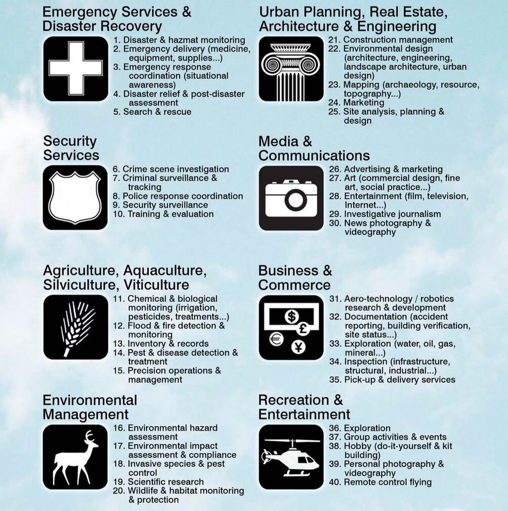
Our ServicesThe possibilities are endless for what we can do for you and your business. The technology of Unmanned Aerial Vehicles and Drones is quickly expanding.We are approved to conduct:
|
Advantages of Drones
|
Consulting Services
Our experience enables us to share useful information with people who need to make informed decisions. If you are a decision maker and need professional input SkyHunter 406 can help. We can work with you through various stages in your proposed or existing drone investment.
Through consultation we can provide the following amongst other specialized services.
- Presentations to individuals or groups, format and topics are client driven
- Vendor selection
- Hardware/software selection
- Platform selection
- Assistance in presentations to stake holders
- Roll out and support logistics
- Rules and legal permits
- Operational and safety guidelines
- Flight instruction training
- Hiring of qualified UAV pilots
- Arranging UAV service contracts